|
|
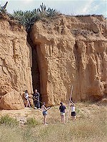
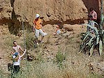
Flash flood hazard and river
management.
The Riera de Ribes is normally a dry river and the investigation is based on
a historic flood notch on a river cliff.
The river flood cross-section and gradient are measured. Discharge is
calculated using the hydraulic radius and Manning n formula.
The risk to recent housing and camp site developments on the river floodplain
downstream can be assessed together with the effectiveness of river management
schemes.
|
This study introduces the concepts of
river efficiency and competence.
Other factors that affect the flood risk, such as increased urbanisation,
forest fires, changing agricultural land use, drainage density, drainage basin
shape, reforestation, etc. can be analysed with the aid of secondary data.
The study can include a visit to the nearby flash flood management scheme in
El Vendrell.
|