The Rhine Floods 1995: Flood Prevention
1. Flood proofing
Floods are a natural event and only become a hazard when they affect people of property. People have chosen to build their homes close to the river and can take precautions such as:
-
house design which raises the floor level above normal flood heights;
-
interior room design which minimises flood damage, e.g. tiled floors;
-
light furniture which can be quickly and easily moved upstairs should a flood occur;
-
Removable flood walls that can be opened in summer to provide a river view.
Local authorities are now controlling the location of new buildings and the construction methods used, so that buildings are able to cope with floods when they occur.
2. Dams and reservoirs
Built upstream for hydro-electricity and to regulate river flow. The aim is to help prevent flooding and to release water gradually in times of low rainfall in order to make the river navigable all year round. Dams are multipurpose schemes which:
-
control flooding
-
provide a water supply
-
produce hydro-electricity
-
improve navigation
-
increase afforestation
-
reduce soil erosion
-
encourage industry
-
encourage tourism
3. Flood Retention Basins and Impounding Dams:
'Impounding Dams' are valleys filled with water which provide drinking water, produce electricity or supplement low flows. The water stored in impounding dams is drawn off from flood waters and during flood periods the water is merely moved for a time from one place to another. 'Flood Retention Basins' are only filled with water during periods of flood, after which they are emptied in order to be ready for the next flood.
4. Increasing the height of the levées
It has been suggested that higher embankments should be built and the river deepened but, where this has been done, (e.g. the Mississippi) it has produced rivers flowing many metres above the surrounding floodplain. As the levee is built up, sediment in the river grows too; the river beds – and the water levels rise. This leads to disaster when the barriers collapse.
5. Flood relief channels
To siphon off the Rhine flood water when the delta near the sea becomes overloaded.
6. Making the course straighter and shorter
This aims to get rid of the flood water as quickly as possible. By shortening the distance, navigation is made easier, but the gradient and therefore the speed of the river is increased.
7. Afforestation
Trees delay and reduce the amount of water reaching the river.
8. Floodplain land use zoning
Land can be zoned for uses that will not be damaged by winter floods e.g. pasture, forestry and parks
9. Floating Towns
The Dutch are pioneering floating towns to cope with rising tides and river flooding. In the short term, however, floating houses are no replacement for conventional flood defences.
10. Room for the River
This reflects a new philosophy that humans should adapt to the shape of river basins that naturally result from flooding histories. This programme is currently being translated into land use change and relocation of inhabitants and dykes on certain floodplains. Arable land is being converted to forest, marsh or wet grazing meadows. Inhabitants are being relocated, with compensation, to higher elevations, and dykes are being relocated back from the main channel such that the entire floodplain cross section can accommodate a much larger volume of water.
Measures taken include:
-
An increase in 'water meadows' which can be allowed to flood when necessary. The sealing of the soil surface with tarmac or concrete in vulnerable areas is being limited to slow the water run off into the rivers.
-
Ground coverage of vegetation with woodlands and grasslands is being increased.
-
The use of fertilisers on soil is being very carefully monitored because these affect the soil structure and its ability to retain water.
-
Adequate maintenance of dykes and flood walls.
-
To allow more space for trees on the floodplain, metres of silt accumulated over many years has been stripped and deep trenches constructed. (See diagram below).
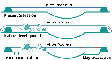
Room for the river: floodplain management |
Coordinated water management policies across national borders is necessary if winter floods are to be avoided in the future, e.g. buffer zones, dykes, water flow regulation. The job of developing these flood control measures will cost hundreds of millions of pounds. However, if they are adopted, not only will the dangers of flooding be reduced but they will also help to protect the environment in areas along the banks of the affected rivers. It must not be forgotten though that flooding is, for the most part, controlled by nature and humankind can influence the impact of flooding to a limited degree only.