Geography
Biology
Geology
Business Studies
 
Expand All  |  Collapse All
 
GCSE
Animations
Forum
Google Compass
Google Earth
Google Street Maps
OS Maps Compass
Coursework
Coursework Helpline
El Raval
Planning
Designing
Introduction
Data Collection
Data Presentation
Analysis
Organisation
Edexcel A Exam
Syllabus
Assessment Scheme
Assessment
Core Paper
A1 Physical
A2 Human
A3 Economic
A4 Natural World
Option Paper
B5 Environment
C8 Urban
Revision
Core Paper
A1 Physical
1.1 Rivers
New item
1.2 Glaciation
New item
1.3 Coasts
New item
A2 Human
2.1 Pop Change
DTM
Change
2.2 Pop Structure
Dependency
Ethnic
LEDC/MEDC
Rural/Urban
2.3 Settlements
LEDC Land Use
MEDC Land Use
Site & Situation
Urban Zones
Zomba
A3 Economic
3.1 Sectors
Structure
3.2 Farming
Systems
Factors
EU
Agribusiness
Costa Polythene
LEDC
3.3 Industry
Location
Location Change
High Tech
Multiplier Effect
Formal/Informal
TNC
A4 Natural World
4.1 Weather
Air Masses
Frontal Rain
Relief Rain
Anticyclones
Synoptic Charts
4.2 Climate
Climate Factors
Climate Types
4.3 Forests
Distribution
Adaptation
Case Study
Option Paper
B5 Environment
Barton on Sea
Causes & Effects
Management
Evaluation
Rhine Floods
Background
Causes
Effects
Management
Evaluation
Farming
East Anglia
Causes & Effects
Evaluation
Sahel
Causes & Effects
Evaluation
Exploitation
Doņana
Causes & Effects
Issues
Rain Forest
Timber Extraction
C7 Tourism
Growth
Multiplier Effect
Causes
Classification
Impact
Impacts
Machu Picchu
Attractions
Impacts
Groups Affected
Sitges
Attractions
Impacts
Groups Affected
Management
Contrasts
Machu Picchu
Attractions
Management
Attitudes
Maldives
Attractions
Management
Attitudes
Yosemite
Attractions
Problems
Management
Attitudes
C8  Urban Areas
Barcelona
Inner City
Urban Sprawl
Management
Pollution
Causes
Management
Attitudes
Sao Paulo
Management
Glossaries
Coasts
Farming
Glaciation
Industry
Population
Rivers
Settlement
Urban
Weather
Tests
Air Masses
Anticyclones
Coasts
Economic Change
Glaciation
Grid References
LEDC Urban Land Use
Map Bearings
Map Reading
Population Change
Population Structure
Rainforest Management
Rainforest Vegetation
Rivers
Weather at a Front
Test Users Online
Active Test Users
Change Name
Chat
Your Data
Your Data Log
Other Support
Classroom Support
Classroom Support
Coursework Examples
Coursework Helpline
Site Data
Password Protection
Extended Learning
A Level
Geo Factsheets
Google Compass
Map Reading
Year 7
Year 8
Year 9
Fieldwork
Data presentation
Methodology
Sampling
Techniques
Geography Links
Geo Factsheets
Web Links
Test Support
Capital Cities
Describing Places
Glossaries
Google Compass
Map Reading
Open or Free Text
Test Troubleshooting
Using a Compass
Home Page
June 19, 2013
Availability | Prices 2013 | Prices 2014
 

Mediterranean Tourism Seasonality


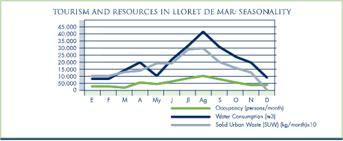
An important feature of tourism in the Mediterranean basin is its strong seasonality. Most tourists travel during August and no less than 40% of all arrivals are registered in the peak months of July, August and September. Such a strong seasonality dictated by the weather, gives rise to two problems:

1. The need to optimise the use of the tourism infrastructure such as roads to accommodate high flows during the summer, and to redistribute tourist flows to reduce the risk of high unemployment during the rest of the year.

2. From an environmental perspective, during the hot and dry months, both domestic and international tourism are heavily dependent on water resources, and this pressure may cause depletion of the resource base.

In dryer regions like the Mediterranean, the issue of water scarcity is of particular concern. Because of the hot climate and the tendency of tourists to consume more water when on holiday than they do at home. It has been estimated that a Spanish city dweller uses some 250 litres a day, while the average tourist uses 440 litres. With an allowance for watering gardens and golf courses and filling swimming pools, this can rise to some 880 litres per day for visitors in luxury accommodation.

The diagram below shows the effects of seasonality on the resource base of one Catalan Mediterranean resort. Lloret de Mar is a town in north-east Spain covering 47 kmē whose permanent population of 20,000 inhabitants increases to a peak of 180,000 in the summer, receiving almost 4 million tourists each year.


Note: Although the source consulted (Costa Brava-Girona Board of Tourism-INSETUR) indicates a maximum occupancy of approximately 100,000 persons, other sources have reported significantly higher occupancy rates for the month of August, with peaks reaching above 180,000.

Sources:

1. Costa Brava-Girona Board of Tourism, Lloret de Mar Town Council, Serveis Integrals Lloret, S.L., 1998.
2. http://www.lloret.org/uk/agendaxxi/presentacio.htm


  Copyright © 2013 All Rights Reserved Barcelona Field Studies Centre S.L.  
Page update 5/05/13