The impact
of coastal development pressures on fragile habitats
Location: Gava
Travel time: 30 minutes
Study time: full day
This fieldwork investigates the threats to fragile sand dune
ecosystems along the coastline to the southwest of Barcelona. It examines the
impact of human activity, the variations in biodiversity between managed and
unmanaged dunes, and the success of dune management schemes.
The construction of the Gava coastal walkway aims to protect the dune ecosystem
mainly by reducing extensive trampling. Landscape architecture must deal with
the abiotic and biotic processes of the dune system and the Gava coastal walkway
has been developed to achieve these goals.
Managed dune ecosystem at the Gava coastal
walkway (February 2008)
Unmanaged dune ecosystem at the Gava coastal
walkway (February 2008)
Contrasts may be drawn with the protected sand dunes at the
nearby Llobregat Delta Nature Reserve. Access is restricted to permit holders
and field visits are not possible during the Spring nesting season.
Protected dune ecosystem at the Llobregat Delta
Nature Reserve
When
development and conservation meet head on: Platja Llarga, Vilanova
Location: Vilanova
Travel time: 15 minutes
Study time: half day
There are economic benefits and environmental
costs to coastal development which influence the success of the development
equation. Platja Llarga at Vilanova, near Barcelona provides a local case study
where the costs were perceived to outweigh the benefits and development
pressures were blocked by local action.
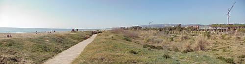
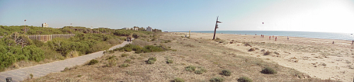
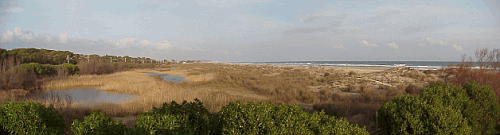
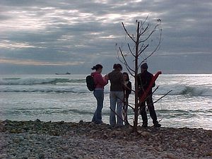
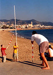
Platja Llarga, Vilanova Barcelona (February
2008)
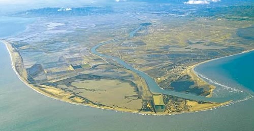
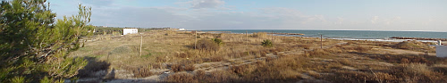
Platja Llarga was a large area of coastal
wetland and dunes, forming part of the delta of the River Foix. Today, although
badly damaged, it remains one of the last undeveloped sites along the Catalan
coast.
This fieldwork assesses the beneficial economic impacts of the
Platja Llarga development against the environmental costs and examines the views
of stakeholders and their conflicting needs. Field study methodology includes
the use of conflict matrices, cost-benefit and values analysis and environmental
impact assessments. Questionnaires may be used to gather the views of local
residents and businesses.
When
development and conservation meet head on: Els Muntanyans
Location: Els Muntanyans, Torredembarra
Travel time: 20 minutes
Study time: half day
Els Muntanyans on the Costa Dorada provides a
contrasting case study of development pressures where costs are perceived to
outweigh the benefits. Development has recently been slowed by court action
(February 2008).
Els Muntanyans, Torredembarra (February 2008)
Planning permission has been given for the
construction of 550 homes, parks and facilities on the edge of coastal marshland
and dunes at Els Muntanyans in Torredembarra. The development is located at the
mouth of the Gibert torrent and covers the biological corridor that connects the
adjacent beach and Protected Natural Area of Interest (PEIN), with the protected
rural interior. The beach is the only large remaining natural beach between the
Llobregat Delta to the south of Barcelona and the Ebro Delta.
This fieldwork assesses the beneficial economic impacts of the
Els Muntanyans development against the environmental costs and examines the
views of stakeholders and their conflicting needs. Field study methodology
includes the use of conflict matrices, cost-benefit and values analysis and
environmental impact assessments. Questionnaires may be used to gather the views
of local residents and businesses.
The impact of coastal erosion and coastal management strategies
Location: Sitges, Barcelona
Travel time: 15 minutes
Study time: full day
Sitges shingle beach
Sitges sand beach
This study investigates the coastal
processes, management and issues focusing on the threat to the Sitges beaches.
Many Catalan beaches are losing their sand. Recent storms have starkly
revealed this problem and the long term solution is a complex one.
Evidence for longshore movements and dominant wave directions can be gained
through a study of pebble long axes and alignments on a nearby shingle
beach. Hypotheses can then be applied to a study of the sand beaches that
are under threat.
The study includes an evaluation of the success of the current coastal
management schemes and an assessment of alternative management strategies.
This case study forms the focus of a recent Eurosion report on coastal erosion and
management.
Location: Ebro Delta
Travel time: 1½ hours
Study time: full day
The integrated coastal zone management plan for
the sustainable development of the Ebro delta is currently being prepared
Ebro Delta
IMPACTS
PRESSURES
Coastal erosion and subsidence
Regulation of Ebro river water levels
Eutrophication and loss of ecological potential in saltwater
marshes
Modification of the channel network and influx of water and
sediments into the rice fields
Polluted, eutrophied bays with high rate of silting
Excessive use of pesticides and fertilisers
Modification of river flow rate: saline wedge intrusion and loss
of water quality
Land occupation through development
Loss of riparian forest and vegetation
Increased pressure of tourism
Reduction and fragmentation of natural areas, habitats and
communities
Deficit of infrastructures and facilities
Loss in quantity and quality of fishing resources
Variable hydrological management that has not been jointly
agreed by all agents
Marine pollution
Impacts and pressures in the Ebro Delta area
The risks associated with the Ebro Delta are:
1. Climate change
2. Loss of rice growing areas (the EU’s CAP 2013)
3. Unplanned and excessive urban growth in inappropriate areas
4. Risk associated with river dynamics: modification of water flow rates,
pollution phenomena, and riparian degradation
5. Construction and implementation of new infrastructures without proper
evaluation of impact of strategic planning (marine wind farms, intensive
aquaculture, etc.)