Ebro Delta: Evolution
Physical History of the delta.
The Ebro delta is the most important aquatic environment in the western Mediterranean after the Camargue and the second largest in Spain after the Coto Doñana National Park. Its 320 km² form the most important wetland in Catalonia.
Evolution of the Delta alluvial plain
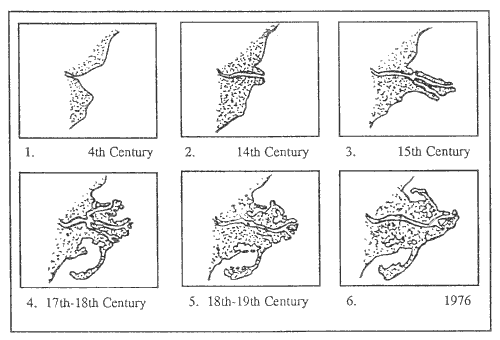
The current delta dates from the end of the last ice age when eustatic changes lead to its growth. Sediment was transported by the Ebro river and acted upon by marine, wind and river processes while successive changes in sea level allowed progressive and rapid growth over the sediment platform. The period of most accelerated growth was in the 15th and 16th centuries when large-scale deforestation of the Ebro river basin for agriculture and ship building occurred. This caused widespread soil erosion which contributed large amounts of sediment to the river and its delta. Thus the delta is a relatively recent feature on the Mediterranean coastline. Indeed, the old town of Amposta, a seaport in the 4th century, is now located 25 km from the river mouth.
As the diagrams above show, the delta has continually changed its form and many river mouths or 'goles' have been created and abandoned. Many of the previous distributaries provided the points from which the sediment used to build the two extensive sand bars reached the sea and after their abandonment these subsequently formed the freshwater lagoons.
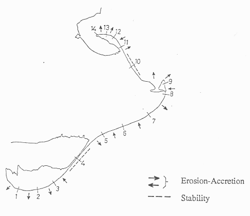
Parts of the delta are now eroding as shown below. There are areas of the delta where the annual retreat is between 6 and 7 metres per year, and the problem is getting worse. The lack of sediment contributed from the River Ebro is behind this disappearance. There are now 187 dams on the river, and most sediments settle in front of the dams instead of reaching the delta and the sea. Regular winter river floods used to cover the land in new sediment, compensating for natural subsidence caused by compaction of the soil. These winter floods no longer occur as the waters of the Ebro River have been managed and diverted for summer irrigation of the rice fields. Humans, who indirectly drove the growth of the delta, are today contributing to its destruction. Past disagreements over the level of threat of coastal erosion have been replaced by a general consensus that the very existence of the delta in its current form is now at risk.
|
|
The modern delta has been and is intensely transformed by human activities and most of the area is now dedicated to agriculture -15,000ha. of rice and 9,000ha. of market gardening and fruit orchards. Large expanses of beaches, marshes and salt pans and lagoons still exist. Over 90km of unspoiled beach remain in addition to two large open sea bays enclosed by sand bars. Both of these sand bars enclose vast expanses of shallow water which are important for waders and gulls. This last type of environment is rare in the Mediterranean due to the low tidal range and is therefore of great importance.
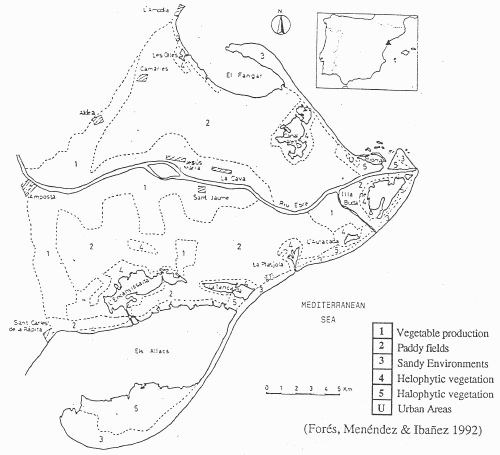 Map of Ebro Delta showing the location of the Coastal Lagoons and the Land Use |
All of these environments suffer from intense hunting, fishing and recently fish farming pressures.
Factors affecting Delta form
Where rivers reach the sea and are checked by the coastal processes deposition may occur. In conditions where coastal erosion is slight or sea level changes are taking place the formation of a delta may result. Such coastal wetlands are environmentally diverse and have dynamic hydrological systems where freshwater, brackish and sea water all contribute to the complex underground layers of the groundwater. Zonation is common as are the processes of natural vegetation succession and colonisation.
Deltaic formations
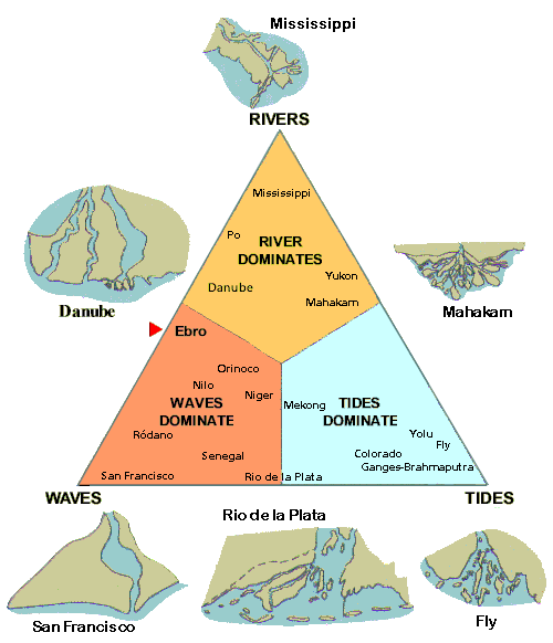 |
This is a diagram of the deltaic formations in accordance with the relative importance of the river deposits, the force of the waves and the influence of tides. The shape of the Ebro river delta would be the consequence of a position of relative balance between the river deposits and wave erosion, in an area uninfluenced by tides. This position can change in time. This would be the case if, for example, the solid river deposits diminish, due to the use of water for hydroelectric and irrigation purposes.