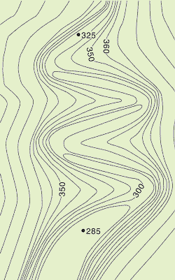
Expand All  |  Collapse All
 
Map Reading
Map Reading Test Help
Using a compass
Watch as compass
Contour Analysis
River Valleys
Map Symbols
Abbreviations
Footpaths
General
Hills
Railways
Roads
Tourism
Water
Tests
Compass Reading
Grid References
Map Bearings
Map Reading
Other Tests
Test Troubleshooting
Test Users Online
Active Test Users
Change Name
Chat
Your Data
Your Data Log
Home Page
Availability | Prices 2008 | Prices 2009
 

Reading Contour Lines: Identifying Valleys

The map below shows the contours of a river valley. Roll over the buttons to find the river that correctly matches the contours. Click on the buttons to check your answer.

Rivers flow downhill, usually along the lowest land on the map. When contour lines cross a valley, they form a 'V' shape, with the point of the 'V' always pointing uphill.

IS THIS YOUR FINAL ANSWER ?

IS THIS YOUR FINAL ANSWER ?


  Copyright © 2008 All Rights Reserved Barcelona Field Studies Centre S.L.  
Page update 6/06/08