| Capital Cities | ||
| Describing Places | ||
| Glossaries | ||
| Google Maps Compass | ||
| Map Reading | ||
| Open or Free Text | ||
| Test Troubleshooting | ||
| Using a Compass |
| Atlas Test | ||
| Capital Cities | ||
| Describing Places 1 | ||
| Describing Places 2 | ||
| Describing Places 3 | ||
| Grid References |
| Capital Cities | ||
| Describing Places | ||
| Glossaries | ||
| Google Maps Compass | ||
| Map Reading | ||
| Open or Free Text | ||
| Test Troubleshooting | ||
| Using a Compass |
| Atlas Test | ||
| Capital Cities | ||
| Describing Places 1 | ||
| Describing Places 2 | ||
| Describing Places 3 | ||
| Grid References |
Computer Graded Map Reading Skills Test
This page opens a computer graded map reading skills test with secure authenticated certificate awards and diagnostic feedback. A certificate with your mark, grade and other diagnostic information can be printed at the end of the test. The test is aimed at improving your map reading skills using a hill walking simulation exercise.
Task Details
Your role as the leader of a small group of hill walkers requires you to use your map reading skills to plot the shortest and safest route to the summit of Britain's highest mountain, Ben Nevis. Starting from the car park, you create a red trail on the map through mouse clicks, identifying and avoiding hazards that could jeopardise the safety of your party. Your route will be marked and graded, and near misses, (accidents or 'close calls' that do not result in injury), recorded. You must abandon the walk if there are injuries or deaths...
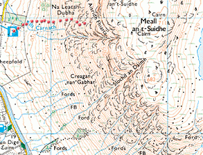 |
| Test map extract showing route-plotting example |
The test features:
![]()
Warning
For any hill walking, it is essential to be properly clothed
and equipped, and also have the ability to use a map and compass.
Weather conditions on mountains can be severe. Sunshine can change to
treacherous arctic-like blizzards in minutes. There have been serious accidents
and deaths in the Spanish mountains, even in Summer, often through a lack of
skill, proper clothing, emergency survival equipment or good judgement.