Impacts of coastal development
Describe the fieldwork and research you would undertake in
order to investigate the impacts of coastal development (15 marks)
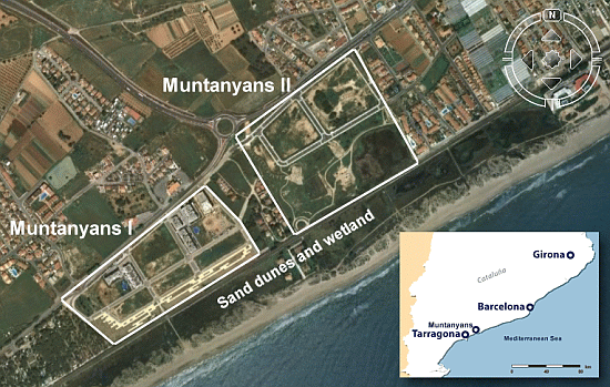
Muntanyans II is a development project on the Catalan coast, 50 km south of
Barcelona (see Figure 1). Over 500 homes, parks and facilities are planned to
cover 173,900 m² of land on the edge of fragile coastal marshland and dunes,
home to a number of endemic threatened species. This is a second phase of
construction at the site, with the adjacent Muntanyans I development already
completed but, because of the financial crisis, currently largely unoccupied.
 |
| Figure 1: Location of the Muntanyans development |
There are a number of social, environmental and economic impacts that can be investigated. Fieldwork may include a study of the impact of the development on the fragile dune vegetation, as well as the use of field sketches, environmental impact assessments and conflict matrices. Questionnaires and interviews may be used to gather the views of local residents, businesses and the local council. A range of historical documents may be used to research the impacts, including newspaper extracts. Historic maps and photographs may be compared with recent images from Google Earth.
Fieldwork to investigate the impact of the Muntanyans development on the dune vegetation
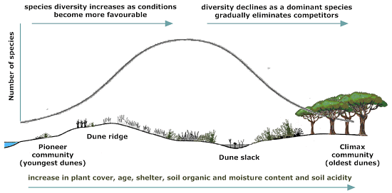
Sand dunes close to the existing Muntanyans I development may show the impact of greater visitor numbers, since dune vegetation is very fragile and easily damaged by trampling. These dunes may be compared with dunes in a more isolated location and a number of hypotheses tested, based on the concept of vegetation succession, illustrated in Figure 2.
 |
| Figure 2: Succession in a sand dune ecosystem |
Hypotheses
That the more accessible (disturbed) dunes will have:
• lower vegetation diversity
• higher wind velocities
• greater erosion
• lower organic content
• less acidic pH values
Fieldwork methodology
The fieldwork would involve laying a transect line across the dunes using
ranging poles. The sampling would be stratified, with vegetation sampled on the
ridges and slacks where changes in species occur. To avoid bias, a table of
random numbers should be used to select the sampling sites.
Vegetation should be sampled using quadrats, the quadrat size determined by an
optimum quadrat size technique. The number of species should be identified and
counted and recorded as a percentage of the quadrat size. The percentage of bare
sand should also recorded.
Wind velocities could be measured using an anemometer, and soil samples
collected for colour comparisons, pH testing and laboratory analysis of organic
content and moisture content.
Research
Research using newspaper archives and maps suggests that the Muntanyans II
development will eliminate the only remaining biological corridor on the coast
of northern Tarragona linking the rural interior and the coastline.
Research has also revealed that in the past, flood water from the River Gibert
was able to spread slowly across the Muntanyans II site and gradually infiltrate
the soil. The drainage channel was ill-defined, but canalisation now
concentrates and speeds the flow, directing it towards the main coastal rail
link which lies a short distance between a soakaway and the sea. An impact study
carried out by the University of Barcelona has concluded that the Muntanyans II
site is in a high risk flood zone where flood waters from the River Gibert
accumulate. The canalisation of the Gibert will not stop the flood risk since
the direction of the waters "are uncontrollable and the nature of the
terrain directs them towards the planned housing development".
The canalisation of the River Gibert may alter the supply of fresh water to the
coastal wetlands, resulting in a water deficit in some areas, and a surplus in
others. As the soakaway at the mouth of the Gibert becomes blocked by sediment,
a new lake may form.
Additional research could be carried out into the possible alteration of the
water dynamics in the area caused by runoff from the urbanisation. The increase
in freshwater input to the system can unbalance soil salinity with subsequent
modification of existing vegetation.
Research could also be carried out into the impact of the development on the
extensive offshore meadows of Mediterranean seagrass (Posidonia oceanica).
Seagrass forms the first trophic (feeding) level of the marine ecosystem.
Seagrass meadows have other important ecological functions. They improve water
quality by reducing the particle loads in the water and absorbing dissolved
nutrients. Seagrass meadows dissipate wave energy and protect the coastline. In
addition, a significant fraction of seagrass production accumulates on the
beach, as seaweed, where it contributes to dune formation. The seagrass could be
affected by runoff and pollution from the Muntanyans development.
The wider economic impact of the development is also an area that requires research. The development was built at the height of the construction boom, most of the Muntanyans I properties remain unsold, and the Muntanyans II development has been halted by legal action. It seems unlikely to be completed, given the enormous oversupply of new property (estimated 1.2 million homes) on the Spanish market.
Coastal Development Pressures: Els Muntanyans, Torredembarra
