Extreme Weather
Field studies have been developed to support the Edexcel GCE Geography Extreme Weather module.
|
Extreme Weather in the Barcelona area
Floods are a common characteristic of Mediterranean water cycles. In the Barcelona region, there have been major floods in 1962 (with possibly 1,000 people dead), 1971, 1988 and 1994. Local flash flooding is becoming increasingly important, especially in the rapidly growing coastal plains north and south of the city. Diffuse inundation after storms with intensities of 200 mm/day or more is also becoming common. Flash flooding occurred in the Barcelona area between 11 pm local time of the 9th of June and 11 pm local time of the 10th of June 2000. The maximum rainfall was recorded over the Llobregat basin, on the Montserrat Mountain, with 224 mm, more than 80% recorded in less than 6 hours. The Vendrell area had a maximum of 134 mm falling in less than 3 hours. This led to flooding of tributaries of the Llobregat River and wadis that are normally dry. The estimated damage was more than 65 million euros and 5 people were killed. However, this has not been the most catastrophic flood event recorded in the lower part of the Llobregat basin. On September 20, 1971, 308 mm were recorded in 24 hrs, with 19 deaths and damage estimated at $100 million. On this occasion, the peak flow of the Llobregat River in Martorell (Montserrat) was 3080 m³/s, more than twice the peak flow produced in the June 2000 event. On September 25, 1962, 250 mm were recorded in 2 hours near the Llobregat basin causing 441 deaths and 374 missing. The analysis of ancient archives since the 14th century shows that catastrophic floods have affected this area once or more each century, mainly in autumn. However, during the 17th, 18th and 19th centuries, some catastrophic floods were recorded in Spring. |
Fieldwork covers extreme impacts, increasing risks and managing extreme weather.
Extreme impacts
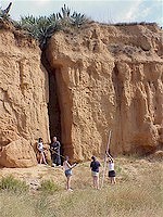
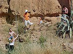
Fieldwork includes a study of flood impacts along the Torrent del Lluc in El Vendrell, investigating features of the floodplain and the flood management schemes.
|
Extreme Impacts
Flash flooding occurred in the Barcelona area on 10th June 2000. The maximum rainfall was recorded on the Montserrat Mountain, with 224 mm recorded in less than 6 hours. The Vendrell area had a maximum of 134 mm falling in less than 3 hours. The intensity was such that a state of emergency was declared in El Vendrell. Vendrell lies at the confluence of two normally dry rieras (intermittent streams), the Riera de la Bisbal and the Torrent del Lluc. The confluence of these two rivers flows across a main road into the town. The Riera de la Bisbal had benefited from canalisation through the town, but the Torrent del Lluc remained as a natural channel, running at the same level as the main road in several locations. Flooding from the Lluc seriously affected dozens of homes and businesses in the town centre. A number of river management schemes have since been implemented along the Lluc to prevent a repetition of the disaster. These have had unexpected consequences. The study examines the social and economic impacts of the floods, investigating and mapping features of the floodplain of the Torrent del Lluc. The effectiveness of the management responses is evaluated. |
Increasing risks
Fieldwork investigates the flood risks associated with the Riera de Ribes.
|
|||||||||
Managing extreme weather
A study of the flood management schemes in El Vendrell enables an evaluation of the success of the existing strategies and how these might be developed or improved in the future.
|
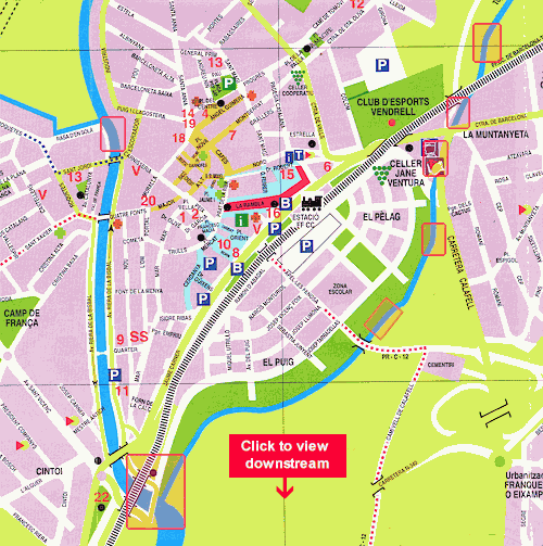
Click on map rectangles to view river management examples
Scale: 1 cm = 100 metres |
All fieldwork is supported with secondary data. These fieldwork studies take a full day.
Edexcel AS Geography Unit 2: Geographical Investigations