| Rebranding
Cities: urban rebranding strategies and their impact
Location: Barcelona: El Raval or 22@ New Technologies district
Travel time: 45 minutes
Study time: full day
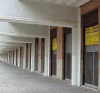
The transformations taking place in Barcelona’s urban
landscape in the last 20 years have given place to what is now internationally
known as the Barcelona model. In the process, old industrial districts have
disappeared to make room for a new, glossy city. As Barcelona has reinvented
itself, there has been a transition from an industrial to a postindustrial city
and tourism has become one of its most defining industries.
 |
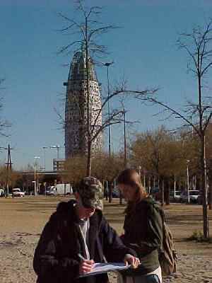
| 22@ New Technologies district |
The city used two high-profile international events as a
catalyst for its radical urban renewal. The 1992 Olympic Games led to the
beginnings of change in Barcelona's once infamous El Raval inner-city district
and the transformation of a blighted coastline of abandoned factories and toxic
beaches. The 2004 Universal Forum of Cultures enabled the completion of the
seafront remodelling, and in the process created a strong legacy momentum.
Growing levels of private investment have gone hand in hand
with increasing levels of infrastructure development and the city is currently
undertaking some of the biggest development projects in Europe. For example, the
old inner-city industrial area of Poblenou, is being redeveloped to create a new
technologies zone, 22@, designated for media, marketing and other
service-related activities.
Field studies focus on the impact and evaluation of a range of
urban rebranding strategies in two contrasting areas: El Raval and the 22@ New
Technologies, Media Park and Forum districts.
Each area study takes a full day.
The
'new look' Raval: an urban rebranding success?
22@ New
Technologies district
Media
Park
Universal
Forum
22@
City promotion
Urban
rebranding
|
|
|
|
| Rebranding
for a sustainable future
Location: Barcelona: 22@ New Technologies Zone, Media Park,
Olympic Village, Diagonal Mar, Universal Forum and La Mina
Travel time: 45 minutes
Study time: full day
Barcelona's 1992 Olympics and 2004 Forum events were the
catalysts for the reclamation of its waterfront west of the River Besňs, an
area formerly known as the 'Catalan Manchester' for its predominance of old
manufacturing industry. Redevelopment has transformed the district, adding the
Olympic Village and Port, new beaches, a riverside park, Diagonal Mar, the
Forum, the 22@ New Technologies zone and Media Park. Other major developments in
the area are in progress, including a high speed rail link and the sinking of
Gran Via, a major avenue, below ground.
This district forms an excellent case study of city rebranding for a sustainable
future, with a range of examples of sustainable city planning strategies and new
infrastructure that meet many social, environmental and economic criteria, as
well as the use of a range of legacy facilities.
The transformation has not been without conflict. The origins
of the Barcelona model go back to a period where local governments made
decisions on urban planning in close consultation with its people, with the aim
of creating a fairer city for its less privileged citizens and in the public
interest. Solutions to conflict often resulted in the creation of more social
and public spaces. Solutions today are less easy when the choice is between
preserving engineering workshops or replacing them with clean buildings housing
new technologies.
| Rebranding for a sustainable
future: 22@ High-Tech Zone, Media Park, Olympic Village, Diagonal Mar, Universal
Forum and La Mina |
|
 |
| Torre de Agbar - 22@ High Tech zone |
| |
 |
| La Mina - a district of high social deprivation |
|
Impact of urban renewal and
brownfield regeneration schemes west of the River Besňs.
Renewal of an old industrial quarter into a technological district (22@).
The Universal Forum of Cultures 2004 legacy facilities facilities include
hotels and commercial centre facilities, new beaches, residential areas and an
urban park.
These developments lie adjacent to La Mina, the most socially deprived
district in the city.
|
Case study of the impact of these
developments, including land use conflicts.
|
|
|
|
|
|
|
| Eixample, Barcelona |
Travel time: 45
minutes
Study time: full day
|
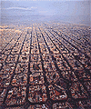 |
| Aerial image of l'Eixample |
|
 |
| One public garden includes an urban beach |
|
Application of urban
models and impact of sustainable city planning. The Eixample is a utopian garden
city development dating from 1859 which grew between outlying industrial towns
across what was then Barcelona's military exclusion belt.
The City Council is gradually restoring public gardens to the Eixample
blocks as part of its ProEixample sustainable city planning.
|
Application of the Hoyt
and Burgess models to the Eixample district of Barcelona. Its growth between
outlying industrial districts is reflected in its land use patterns.
Barcelona's
Eixample
The social, environment and economic impact of the ProEixample garden
project developments. more
|
|
|
|
|
|
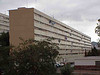
| The Olympic Village: a planning
disaster? |
Travel time: 45
minutes
Study time: full day
|
 |
| Aerial image of the Olympic Village |
|
 |
| Olympic Village: empty streets |
|
The Mayor of Barcelona,
Joan Clos, has blamed low density planning for the lack of social and economic
life in Barcelona's Olympic Village. There are few people on the streets and
public space, shops or bar terraces are little used by the neighbours.
In the Mayor's defence of the compact and dense city – building upwards rather
than outwards – the Eixample of Ildefons Cerdŕ is seen as a success. The
Eixample has 150 dwellings per hectare, creating a district “where yes, there
is life”. For Clos, the Olympic Village with 60 dwellings per hectare is an
example of what should not be done in city planning.
The study compares land use, environmental quality, economic data and
perceptions for sampled Eixample and Olympic Village blocks. The recording of
pedestrian counts and noise decibel levels assists hypothesis testing and
analysis.
Olympic
Village
|
|
|
|
|
| Managing Rural Rebranding: Les
Garrigues |
Travel time:
1½ hours
Study time: full day
|
| |
 |
| Olive trees |
| |
 |
| L'Albi, Les Garrigues |
| |
 |
| Vilosell, Les Garrigues |
|
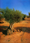
Les Garrigues is a
predominantly rural county situated 100 kilometres from Barcelona.
It is a region traditionally dedicated to almonds and olives, but the farmers
of Les Garrigues are no longer cultivating some 36 per cent of the available
farmland according to data from the Department of Agriculture. One of the causes
of this situation are the low profits gained from cultivation in the unirrigated
zones, a result according to the farmers, of a difficult climate and the lack of
irrigation infrastructure.
This leads to rural depopulation, very evident in some villages with the loss
of services, the number of abandoned fields and growth of second homes.
The EU's LEADER Initiative for integrated rural development has helped
facilitate some 'grass-roots', local development initiatives. Rural tourism is
promoted, focusing on the cultivation and farming of olive trees. Extra virgin
olive oil with the Les Garrigues designation of origin is produced using the
high quality Arbequina olive. Wind farms are a very recent and growing feature
of the Les Garrigues countryside.
The field study focuses on the impact and evaluation of rural rebranding
strategies in two contrasting villages, one remote, the other more accessible.
The day will include a visit to the Les
Garrigues Interpretative Centre at Borges Blanques.
Rural
rebranding
|
|
|
|
|
|
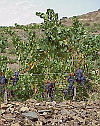
| Managing Rural Rebranding: Priorat |
Travel time:
1½ hours
Study time: full day
|
 |
| Gratallops - the centre of the wine revival in
Priorat |
|
|
| |
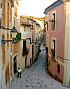 |
| Village street |
| |
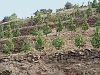 |
| Mountain terraces |
| |
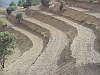 |
| Environmental impact |
| |
 |
| Slate soil |
| |
 |
| Diversification |
|
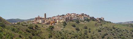
Priorat is a
predominantly rural, sparsely populated region situated 120 kilometres southwest
of Barcelona. The relief is characterised by narrow valleys and steep mountains.
Priorat has a famous winemaking history that began in the 12th century with
the Carthusian monks of Scala Dei. The vineyards are planted on the steep
slopes, which rise from 100-700 metres.
In 1900 an outbreak of phylloxera devastated the region's vineyards, and mass
tourism that pulled people away from Priorat to the coast in the 1960s
accelerated the rural decline. Twenty years ago, the Priorat region was on the
verge of extinction, with grape prices so low that this was one of Spain's most
impoverished regions.
It took a few visionaries to realise Priorat's potential. Most agree René
Barbier initiated the Priorat revival. In the 1980s he established a
co-operative that put its first wine on the market in 1991. From that first
release, the New York Times published an article extolling the virtues of
the Priorat wines and prices soared, with wines commanding more than $300 a
bottle. In barely 15 years, the wines from Priorat have gone from obscurity to
the most expensive in Spain.
Wine tourism has led to the establishment of high quality restaurants
operated by the wineries. This has helped to create a 'Priorat' quality brand
that is now attached to other products in the region. Wine and gastronomic
tourism have thus combined to encourage local development and the agricultural
recovery of a region traditionally considered as marginal.
The field study focuses on the social, environmental and economic impact and
evaluation of rural rebranding strategies in four contrasting Priorat villages,
including Gratallops, the home of René Barbier. Data collection includes
residential quality, environmental quality, perceptions, services and amenities
and environmental impact.
Priorat
Rural
rebranding
|
|
|
|
|
|
| Rebranding declining Spanish
Mediterranean holiday resorts |
Travel time: 15 minutes
Study time: full day
|
|
The Spanish Mediterranean 'Costas' have become a byword for
much that is bad about mass tourism. A model of uncontrolled growth has led to
the destruction of the landscape, pollution, poor planning, loutish visitor
behaviour and loss of national identity. While the costas struggle to hold on to
their package tourists, their booming, cheaper and less-crowded rivals in
countries such as Turkey, Tunisia, Egypt and Croatia enjoy annual growth rates
of up to 50%.
The fall in tourism revenue has been felt hard in the coastal
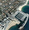
resorts of Sitges and Calafell, two approximately equal-sized settlements lying
to the south west of Barcelona (see Figure 1). Both rely on tourism as a major
source of income and employment and both have rebranded in an attempt to
overcome the decline. The rebranding strategies for the two resorts have
followed very different paths and the study aims to compare the relative success
of tourism, in its various forms, by employing the Butler
Model.
 |
| Figure 1. The location of Sitges and Calafell |
Tourism
rebranding in Sitges and Calafell
|
|
|
|
All fieldwork studies are supported with a wide range of secondary data.
Edexcel
AS Geography Unit 2: Geographical Investigations
|