River Study Locations
 |
|
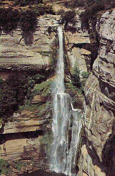
| Salt de Sallent waterfall, Collsacabra | |
 |
|
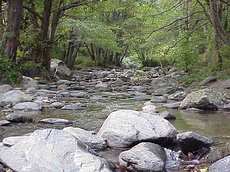
| River Tordera, Montseny Natural Park | |
Barcelona's coastal location and the proximity of the surrounding coastal mountain ranges leads to frequent flash flooding in the region. The channelisation of Barcelona's two main rivers, the Besòs and Llobregat rivers has greatly reduced the flood risk in the city. Many of the seasonal rivers on the outskirts of the city continue to pose flood risks, however. Successful fieldwork can be undertaken in dry river beds using evidence of previous flood levels as the basis for calculating velocity and discharge
A normally dry river channel near Sant Pere de Ribes has evidence of a past flood level line in a river cliff. This level can be used to measure the channel cross-section and with Manning's n formula, the approximate discharge for the flood event. Further downstream, housing developments and a camp site are located adjacent to the river channel. Bank-full discharge can be calculated at this site using the same techniques and the flood risk assessed.
River studies can thus be combined with Hazard Management fieldwork.
For reliable and safe source-to-mouth 'wet' river studies, it is necessary to travel a short distance north of the city, where the Tordera and Tenes rivers provide unspoilt and little-visited locations.
Travelling further afield, spectacular waterfalls, gorges and rapids can be studied in the Collsacabra region, less than two hour's drive to the north of Barcelona. This study can be incorporated within a walk through the Collsacabra region or include a visit to unusual deep meandering wadis en route.
Our most popular river studies are summarised in our fieldwork packages. River field studies