Barcelona Urban Development and Change
Barcelona is a city which provides an excellent case study of many of the major themes of urban development and change, but which also has some unusual and distinctive features that contribute to its particular character and personality. The city lies on a coastal plain constrained by the Collserola hills and the rivers Llobregat and Besos. These topographic constraints have produced urban congestion and high residential densities.
Barcelona has many features typical of the north-west European city. It has a large tertiary sector, its traditional manufacturing industries have been declining, and multinational investment has become increasingly important. The rapid development of Technical Parks for high-tech industry is a modern feature associated with the growth of what is becoming known as the European 'sun-rise' belt, along the Mediterranean coast between Valencia and Northern Italy. Barcelona suffers from serious traffic congestion and has the unenviable reputation as being the second most noisy city in Europe after Sofia.
The well-preserved medieval quarters of Barcelona were constructed on top of a Roman settlement, founded in 15 BC. Examples of the perpendicular Roman streets can be seen beneath the medieval buildings in what is the largest underground excavation of a Roman site in Europe. The area within the medieval city provides an excellent example of historic continuity and the survival in the present-day landscape of an old urban core. The area today is characterised by a maze of narrow streets, alleyways and small squares - a relict urban landscape.
The area to the south of the medieval district, on the other side of a dry river bed later to become the pedestrianised 'Rambla', was El Raval. This was the site of industries too polluting to be allowed inside the main city. El Raval was enclosed by city walls and this was the area where factories and high-rise tenement blocks were constructed during the Industrial Revolution. In the 1850's the city wall strait-jacket was demolished to allow the expansion of Ildefons Cerdà's l'Eixample. Cerdà's plan was the first example of urban planning and was heavily influenced by the ideas of Karl Marx and other social thinkers of the time.
|
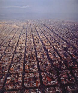
The l'Eixample was planned using an extensive grid-iron pattern. The development rapidly spread to connect Barcelona to the outlying towns, which were incorporated into the city at the turn of the century.
The area of Gracia, for example, was Spain's nineth-largest city before it was swallowed by Barcelona's growth. The rigid blocks of Cerdà's grid give way here to narrow streets arranged haphazardly, and the change in atmosphere is striking. Many streets in Gracia consist of small, two-storey buildings, and a series of small squares.
Cerdà's grid, with wide roads and bevelled street corners was designed for the easy passage of the steam tram along each street. Today it produces a large number of traffic intersections, one of his plan's main failings. Other criticisms arise from the fact that some of his ideas were not properly implemented. In particular, the plan intended a garden city in which two sides of each low-rise block would be left open for small parks and greenery. In the twentieth century, with increasing population pressure and the need for car parking, most of these open areas were developed and infilled. Most of the blocks were increased in height to a uniform eight storeys by developers intent upon maximising their incomes.
To the north on the slopes of the coastal hills, a number of large villas were built in the late nineteenth and early twentieth centuries. These formed a high-class residential zone which, although originally separated from the main urban area, has gradually been engulfed by piecemeal expansion.
|
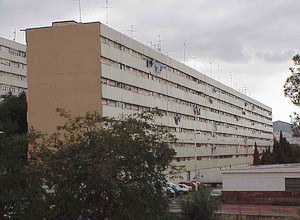
In the period between 1945 and 1975, large areas of high-rise apartments were built along the major route ways and in parts of the urban periphery for immigrants from other parts of Spain seeking work in the city. One such residential district, La Mina, was built specifically to rehouse shanty town dwellers. Today this has a sizeable gypsy community and the greatest social deprivation in the Barcelona metropolitan area.
In the last twenty years, two major events, the 1992 Olympic Games and the Universal Forum of Cultures 2004 have enabled the city to undergo a transformation more radical than perhaps any other city in western Europe.
The City authorities have been able to invest in major infrastructure projects and tackle serious inner city problems. Urban renewal has followed a 'culture-led' approach, with planned gentrification based around high-quality architecture, new museums and hotels.
Changes have been most dramatic in the medieval city, where the striking Contemporary Arts Museum has helped transform one of the city's most rundown districts, El Raval. Gentrification has seen the arrival of many trendy bars and restaurants in the vicinity of the museum, but elsewhere sizeable immigrant communities have taken over apartments no longer wanted by Spaniards.
|
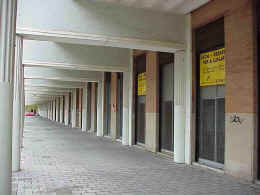
Radical transformation has also occurred in the Poblenou coastal district - an area of old manufacturing industry. In order to house the athletes an Olympic village was constructed on an abandoned factory site. The Olympic Village apartment blocks were designed along the lines originally envisaged by Cerdà, but today much of the planned ground floor commercial space remains empty. Distance from the central business districts of Plaça Catalunya and Zona Alta may be largely to blame, but for the Barcelona Mayor, Joan Clos, the Village with densities of 60 dwellings per hectare, is an example of what should not be done in city planning.
A more recent development adjacent to the Olympic Village, the Diagonal Mar hyper-community, has even lower densities - 48 dwellings per hectare - and is seen by some as an urban development disaster, despite winning an Urban Land Institute Award for Excellence. According to Clos, such low density areas do not contribute to building a sense of the city. In the Mayor's defence of the compact, sustainable and dense city – building upwards rather than outwards – the Eixample of Ildefons Cerdà is seen as a success. The Eixample has 150 dwellings per hectare, creating a district “where yes, there is life”.
|
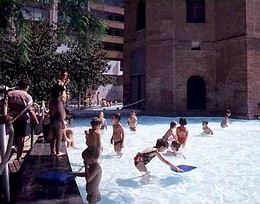
High population densities in l'Eixample today help account for the sense of vitality in the district, and the Barcelona Council are now well underway with plans to restore public gardens to the block interiors, one for every nine blocks. This will enable everyone in the district to have access to public open space within a 200 metre radius.
The driving force behind Barcelona's physical expansion has been the growth of the economy. Remaining factories and workshops in the Poblenou district are being transformed into a zone for new technologies. Southern Europe's new generation synchrotron is being constructed to the north of the city. Business tourism has been boosted by the development of Europe's largest conference centre on the Universal Forum of Cultures 2004 site. The port acts as the point of embarkation for Mediterranean cruises and adjacent to it is Spain's largest industrial estate, Zona Franca.
Zona Franca is the largest and most active industrial estate in Spain and one of the most dynamic in Europe. The industrial estate is undergoing major transformation with various new infrastructure projects being developed. The estate includes a tariff-free manufacturing zone, and has attracted a wide range of multinational manufacturers.
The city's economic growth has, to some extent, been achieved at the expense of the environment, particularly the rivers. Both the Besos and Llobregat rivers are undergoing transformation. A series of river-side parks now line the Besos, and a new water treatment plant is being constructed at the mouth of the Llobregat, together with a nature reserve and new beaches. However, fresh conflicts continue to arise. The expansion of the airport has had a detrimental impact on the Llobregat Delta wildlife and the construction of the high-speed rail link is having very damaging consequences for Barcelona's remaining greenbelt.
With its varied architecture, (particularly that of Antonio Gaudi), cathedrals, opera house, theatres, museums and close associations with many famous artists (including Picasso and Dali), Barcelona is very much an artistic and cultural centre. It is also the capital of Catalunya, one of Spain's most distinctive regions, with its own language, traditions and a strong sense of separate identity. There is a great sense of civic pride within the city and a competitive resolve to always outshine Madrid.
Thus Barcelona provides an excellent example of urban growth, from the middle ages to the present. The city's landscape is clearly a product of its past and its present. It also reminds us that town planning is not simply a modern post-war phenomenon and that the intentions of nineteenth planners were no more likely to be fully achieved than those of their twentieth-century counterparts. Barcelona underlines the way in which modern cities combine major international trends (eg. high-rise housing, gated communities and Japanese investment) with distinctive and local characteristics (eg. Gaudi's architecture and the Catalan dimension).