Frontal Rain in the UK
Frontal Rain
The UK lies in an area where warm tropical air meets cold polar air. When two air masses meet, they do not mix readily due to differences in temperature and density. A front is an imaginary line separating two contrasting air masses. Fronts are areas where rainfall takes place.
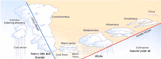
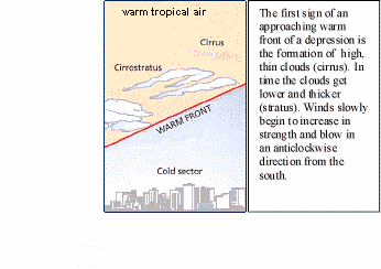
A warm front is found when warm air is advancing and rises over cold air, which is denser and heavier. As the warm air rises it is cooled and condensation takes place.
Continued condensation leads to the growth of water droplets and when heavy enough these fall as rain.
A cold front occurs when heavier cold air is advancing and pushes beneath a body of lighter warm air. The name of the front is specified by the temperature of the moving air.
The diagram below shows the clouds and weather conditions associated with warm and cold fronts.
|
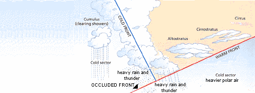
An occluded front occurs when the faster moving cold front catches up and overtakes a warm front forcing the warm air up and off the ground.
 |
Click the above image to view occluded front animation.
Depressions
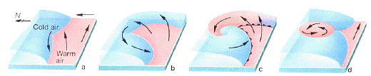
Depressions affect the weather in the UK for much of the year. These are areas of low pressure, bringing unsettled weather of cloud, rain and wind. They form over the Atlantic Ocean where warm tropical air meets cold polar air. Fronts occur where these two different air masses meet and are unable to mix.
The depression becomes more extensive as it moves eastwards towards the UK. By the time a depression reaches the UK it has a warm and cold front. The cold front travels faster than the warm front squeezing the warm sector air upwards between the fronts. Eventually the cold front will catch up with the warm front and, as the warm sector disappears from the ground, form an occluded front. The depression dies out when the warm air has completely risen and cooled. It now has underlying cold air and the temperature differences have equalled out.
The stages in the formation, growth and decay of a depression are illustrated in the following diagram:
 |
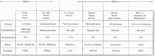
Depressions pass across the country to east and produce a sequence of patterns. (shown below).
The animation below shows the sequence of changes in the
weather upon the approach of a depression:
 |
Air Pressure and Winds in a depression
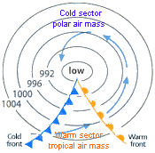 |
In a depression, the light, warm tropical air is forced upwards by the colder, heavier polar air. As it rises, it is spun by the force of angular momentum. An area of low pressure is created on the earth's surface. The lowest pressure is found in the centre of the spinning air. Wind speeds are greatest towards the centre of the spin. The centre of the spinning air marks the centre of the depression.
Differences in pressure are shown on a weather map by isobars, which are lines joining places of equal pressure. Pressure is measured in millibars (mb) and it is usual for isobars to be drawn at 4mb intervals. The closer together the isobars, the greater the difference in pressure (the pressure gradient) and the stronger the wind. Winds follow, or bend slightly inwards from the isobars.