The Rhine Floods 1995: causes of the floods
Causes of the floods: natural causes
Floods are part of the natural water cycle and flooding is, for the most part, steered by natural processes.
-
The immediate cause of the most recent floods, was abnormally high rainfall combined with unusually mild temperatures, which melted mountain snows, to produce a massive torrent of water. Over the past century, average temperatures in southern Germany have increased by between 1°C – 1.5°C. Rainfall in the Rhine catchment area has risen steadily this century and winter precipitation has increased by 40%.
-
The catastrophic flooding might be an early sign of a change in the climate caused by global warming. The growing concentration of 'greenhouse gases' could lead to even milder winters in N.W. Europe and hotter, drier summers.
-
For a large section of its course in Germany, the Rhine flows through a narrow gorge which restricts the amount of land either side available to soak up flood water. This increases the flood problem downstream.
Causes of the floods: human causes
Uncontrollable climatic factors are not the only reasons for the increasingly frequent occurrence of flooding and a number of human-made factors have made the problem worse.
Apart from the river bed, there are four important factors which improve the water storage effect of a river's catchment area and help to control flooding levels:
Vegetation – trees and plants store large quantities of water and also intercept precipitation before it reaches the ground.
Soil – stores water very effectively and can store up to one hundred times the quantity of water as vegetation. It behaves like a sponge.
Ground – Steep land does not retain much water. There is little surface retention in mountainous areas but vegetation on steep land helps to retain water. By contrast, more water is stored in flat areas.
Drainage Networks – small streams, rivers and their water meadows fill up and flood when water levels rise, acting as water storage areas.
When water storage in vegetation, soil, ground and drainage networks is overloaded the drainage situation changes dramatically.
-
Deforestation in the Alps has reduced interception and soil storage of water and increased rates of surface runoff.
-
Urbanisation of the floodplain, with water flowing off roofs and roads into drains leading directly to the river has greatly increased river levels after heavy rain.
-
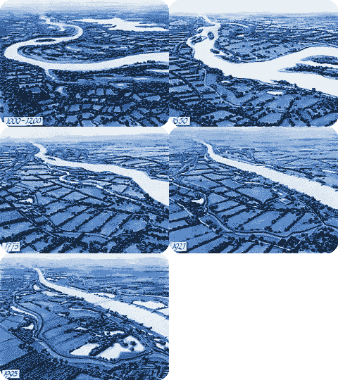
The Rhine, for several decades, has been put into a kind of straitjacket. In the past, excess water would flow out over marshes and floodplains. These acted like sponges, soaking up the water, but since then some of the land has been drained, cemented and asphalted for buildings and roads.
-
The embankments have been strengthened and raised to protect residential and industrial areas, but raising them has closed off former flood meadows. Steep concrete flood walls along the upstream river banks channel flood water quickly from the upper reaches of the river but this has shifted the flooding problems down stream. (Politicians came under pressure to make riverside land available for local businesses or housing).
-
The river Rhine is a major shipping highway. To enable larger barges to use it and to speed up the journey time it has been strengthened, deepened and canalised. When a storm takes place the flow of water (or discharge) does not increase straight away. There is a gap, called a 'Time Lag' between the high rainfall and the peak discharge. A river with a short time lag and high discharge increases the danger of flooding. Stretches of the Rhine have been straightened and banks heightened, cutting some 50 kilometres off the river's 1,320 kilometre meander to the sea. This has doubled the speed of the water's flow from Basle, at the Swiss border, to Rotterdam. Now, when there is heavy snow or rain upstream, water cascades down to flood at the mouth or half-way along, instead of soaking into marshes near its source.
-
Building Hydro-electric power stations along much of the upper Rhine has increased the problem. Since the 1950's, the upper Rhine, along the French-German border, has been changed with the construction of 10 hydro-electric power stations. The 'Power Project' involved building a 'new' river parallel to the old Rhine and the construction of these H.E.P. stations created a deeper, faster Rhine.
-
Changes in farming practices have made fields less absorbent, as hedges and forests have been chopped down to create prairies farms. The drainage of swampy areas, and pumping out the ground water for irrigation purposes have dried out the land even further. The extensive network of cemented farm roads act as extra drainage channels.
|
Click mouse refresh button to restart |
Causes Summary
| Physical | Human |
|
|

