The Rhine Floods 1995
In February 1995 large areas of the Low Countries were deluged with water, and floods threatened many major towns. The Rhine and its tributaries burst their banks in France, Belgium, the Netherlands and Germany.
The Rhine river basin
The River Rhine is the major waterway of the European continent.
It rises in the Alps, flows north and west for 1,320 kilometres (820 miles) and drains an area of 220,000 sq. km before flowing into the North Sea. On its way it passes through Switzerland, Germany, France and the Netherlands (where it is called the River Waal). In the Netherlands the river is in its lower course and it flows into many distributaries. Its tributaries include the rivers – Meuse (Maas), Main, Moselle (Mosel) and Ruhr. 40,000,000 people live either along the Rhine or in its drainage basin. The River Rhine passes through some of the most important industrial areas in the world. 45% of the river pollutants which flow into the North sea comes from the Rhine.
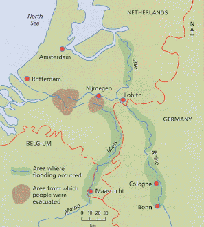
Facts about the floods in the Netherlands:
Background
Holland is a country where 75% of the land is below sea level and, as a result, 15 million people live below sea level. The dykes are the only protection the Dutch have against flooding. In February 1995, the Rhine and its tributaries (the Meuse and the Mosel), burst their banks in France Belgium, the Netherlands and Germany. Large areas of the Low Countries (Belgium, Luxembourg, the Netherlands) were flooded and many major towns were threatened.
The Dutch have defended themselves against the sea for centuries by an elaborate network of dykes 2,500 km (1,500 miles) long but, this time the floodwaters came from the rivers, from water flowing as a result of heavy rainfall in the Ardennes and a flood of melted snow in the Alps. For two years running, levels of flooding have occurred that, statistically, would normally happen only once a century. The flood waters swamped farmland, much of it in the polder regions, where the land had been reclaimed from estuaries and river basins.
A full-scale catastrophe in the Netherlands was avoided, thanks partly to the action to shore up threatened dykes and well-organised evacuation procedures. If the protecting dykes had collapsed the land would be submerged under 20 feet of water. While the dykes are all sufficiently high, the danger comes from water undermining their stability from underneath. Dykes are made of sand and clay and act like a sponge, absorbing water. The longer the exposure the greater the risk of collapse.
Timescale
On 31 January 1995, at Lobith, where the Rhine enters the Netherlands from Germany, the level had risen to 13.48 metres above sea level.
In the Netherlands, at least 4 people were killed , some 250,000 had to be evacuated and large tracts of cities were submerged between 30 January and 1 February 1995 – mostly from the Limburg region south of Nijmegen and from Zeeland, around Rotterdam, Europe's largest port.
On 2 February 1995 there were signs that the dykes around the River Waal were crumbling. The Waal, one of the two Dutch arms of the Rhine, was several miles wide and looked more like the Amazon or the Mississippi than a continental European river. The potential for greatest damage to the environment and property was south of the Waal, to the east of Nijmegen.
Germany, France, Belgium and the Netherlands suffered heavy economic costs in terms of damaged property and lost output.
 |
River Rhine Floods 1995