Expand All  |  Collapse All
 
GCSE
Forum
Google Compass
Google Earth
Google Street Maps
OS Maps Compass
Coursework
Coursework Helpline
El Raval
Planning
Designing
Introduction
Data Collection
Data Presentation
Analysis
Organisation
Edexcel A Exam
Syllabus
Assessment Scheme
Assessment
Core Paper
A1 Physical
A2 Human
A3 Economic
A4 Natural World
Option Paper
B5 Environment
C8 Urban
Revision
Core Paper
A1 Physical
1.1 Rivers
New item
1.2 Glaciation
New item
1.3 Coasts
New item
A2 Human
2.1 Pop Change
DTM
Change
2.2 Pop Structure
Dependency
Ethnic
LEDC/MEDC
Rural/Urban
2.3 Settlements
LEDC Land Use
MEDC Land Use
Site & Situation
Urban Zones
Zomba
A3 Economic
3.1 Sectors
Structure
3.2 Farming
Systems
Factors
EU
Agribusiness
Costa Polythene
LEDC
3.3 Industry
Location
Location Change
High Tech
Multiplier Effect
Formal/Informal
TNC
A4 Natural World
4.1 Weather
Air Masses
Frontal Rain
Relief Rain
Anticyclones
Synoptic Charts
4.2 Climate
Climate Factors
Climate Types
4.3 Forests
Distribution
Adaptation
Case Study
Option Paper
B5 Environment
Barton on Sea
Causes & Effects
Management
Evaluation
Rhine Floods
Background
Causes
Effects
Management
Evaluation
Farming
East Anglia
Causes & Effects
Evaluation
Sahel
Causes & Effects
Evaluation
Exploitation
Doρana
Causes & Effects
Issues
Rain Forest
Timber Extraction
C7 Tourism
Growth
Multiplier Effect
Causes
Classification
Impact
Impacts
Machu Picchu
Attractions
Impacts
Groups Affected
Sitges
Attractions
Impacts
Groups Affected
Management
Contrasts
Machu Picchu
Attractions
Management
Attitudes
Maldives
Attractions
Management
Attitudes
Yosemite
Attractions
Problems
Management
Attitudes
C8  Urban Areas
Barcelona
Inner City
Urban Sprawl
Management
Pollution
Causes
Management
Attitudes
Sao Paulo
Management
Glossaries
Coasts
Farming
Glaciation
Industry
Population
Rivers
Settlement
Urban
Weather
Tests
Air Masses
Anticyclones
Coasts
Glaciation
Grid References
LEDC Urban Land Use
Map Bearings
Map Reading
Population Change
Population Structure
Rainforest Management
Rainforest Vegetation
Rivers
Weather at a Front
Test Users Online
Active Test Users
Change Name
Chat
Your Data
Your Data Log
Other Support
Classroom Support
Classroom Support
Coursework Examples
Coursework Helpline
Site Data
Password Protection
Extended Learning
A Level
Geo Factsheets
Google Compass
Map Reading
Year 7
Year 8
Year 9
Fieldwork
Data presentation
Methodology
Sampling
Techniques
Geography Links
Geo Factsheets
Web Links
Test Support
Capital Cities
Describing Places
Glossaries
Google Compass
Map Reading
Open or Free Text
Test Troubleshooting
Using a Compass
Home Page
February 4, 2012
Availability | Prices 2011 | Prices 2012
 

Damage to fragile environments: farming and desertification in the Sahel

Management issues

Underlying Causes

Cause Effect
Climatic • Droughts are now more common

• High temperatures cause a high rate of evapotranspiration

• Rainfall is infrequent but intense, causing soil erosion

Over population • Overgrazing

• Overcultivation

• Deforestation

• Change in traditional farming practices. Nomads have adopted a more sedentary (settled) lifestyle with no change in traditional herding practices

Growth of Game Parks for tourism or of commercial farming interests. Cash crops take over the prime lands • Reduced grazing land

• Nomads have adopted a more sedentary (settled) lifestyle with no change in herding practices

• Overgrazing, overcultivation and deforestation

Cattle represent wealth and confer social prestige • Overgrazing


Photo credits. Sue White, Richard Wooldridge, Adam Dickinson, Dennis Holmes
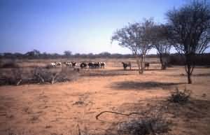
The effects of overgrazing and the need to collect ever increasing quantities of fuel wood from the area surrounding a settlement

Specific Causes

Causes Effects
Overgrazing • Grass is unable to regrow

• Soil erosion

• Desertification

Overcultivation

Farmers forced to grow crops on marginal land

• The continual use of the soil leads to loss of soil structure

• Soil erosion

• Desertification

Deforestation

Trees are removed for fuel and to clear land for crops

• Trees are removed for fuel

• Deforestation leads to soil erosion and:

• reduced transpiration leads to less rainfall in the region

• animal manure being used as fuel. It is no longer available to fertilise the soil, leading to reduced crop yields

• reduced crop cover. Crops are destroyed by the heavy rain when it comes

Click for graphic links:

  • How can land become a desert?
     
  • How have traditional farming practices changed?


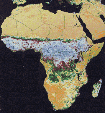
NASA AVHRR (Advanced Very High Resolution Radiometer) Image from 1986 shows the sharp boundary between the deserts to the North and the dense forests to the South on the Sahel

 
  Copyright © 2012 All Rights Reserved Barcelona Field Studies Centre S.L.  
Page update 26/02/11