Expand All  |  Collapse All
 
GCSE
Coursework
Coursework Helpline
El Raval
Planning
Designing
Introduction
Data Collection
Data Presentation
Analysis
Organisation
Edexcel A Exam
Syllabus
Assessment Scheme
Assessment
Core Paper
A1 Physical
A2 Human
A3 Economic
A4 Natural World
Option Paper
B5 Environment
C8 Urban
Revision
Core Paper
A1 Physical
1.1 Rivers
New item
1.2 Glaciation
New item
1.3 Coasts
New item
A2 Human
2.1 Pop Change
DTM
Change
2.2 Pop Structure
Dependency
Ethnic
LEDC/MEDC
Rural/Urban
2.3 Settlements
LEDC Land Use
MEDC Land Use
Site & Situation
Urban Zones
Zomba
A3 Economic
3.1 Sectors
Structure
3.2 Farming
Systems
Factors
EU
LEDC
3.3 Industry
Location
Location Change
High Tech
Formal/Informal
TNC
A4 Natural World
4.1 Weather
Air Masses
Frontal Rain
Relief Rain
Anticyclones
Synoptic Charts
4.2 Climate
Climate Factors
Climate Types
4.3 Forests
Distribution
Adaptation
Case Study
Option Paper
B5 Environment
Barton on Sea
Causes & Effects
Management
Evaluation
Rhine Floods
Background
Causes
Effects
Management
Evaluation
Farming
East Anglia
Causes & Effects
Evaluation
Sahel
Causes & Effects
Evaluation
Exploitation
Doñana
Causes & Effects
Issues
Rain Forest
Timber Extraction
C7 Tourism
Growth
Multiplier Effect
Causes
Classification
Impact
Impacts
Machu Picchu
Attractions
Impacts
Groups Affected
Sitges
Attractions
Impacts
Groups Affected
Management
Contrasts
Machu Picchu
Attractions
Management
Attitudes
Maldives
Attractions
Management
Attitudes
Yosemite
Attractions
Problems
Management
Attitudes
C8  Urban Areas
Barcelona
Inner City
Urban Sprawl
Management
Pollution
Causes
Management
Attitudes
Sao Paulo
Management
Glossaries
Coasts
Farming
Glaciation
Industry
Population
Rivers
Settlement
Urban
Weather
Tests
Air Masses
Anticyclones
Coasts
Glaciation
Grid References
LEDC Urban Land Use
Map Bearings
Map Reading
Population Change
Population Structure
Rainforest Management
Rainforest Vegetation
Rivers
Weather at a Front
Test Users Online
Active Test Users
Change Name
Chat
Your Data
Your Data Log
Other Support
Classroom Support
Classroom Support
Coursework Examples
Coursework Helpline
Site Data
Password Protection
Extended Learning
A Level
Map Reading
Year 7
Year 8
Year 9
Fieldwork
Data presentation
Methodology
Sampling
Techniques
Geography Links
Web Links
Test Support
Capital Cities
Describing Places
Glossaries
Map Reading
Open or Free Text
Test Troubleshooting
Using a Compass
Home Page
Availability | Prices 2008 | Prices 2009
 

Urban Land Use Patterns: LEDCs

The land use model which has evolved is true mainly for Brazilian cities, although it can be applied to other cities in the world, including Zomba in Malawi. The main characteristics of the model of Sao Paulo (below) are:

1. The Central Business District; contains the main businesses, shopping centres and entertainment of the urban area.

2. High status housing surrounds the CBD. This includes high-rise expensive modern apartment blocks, many with their own security guards. This pattern is the opposite to that of cities in MEDCs. Inner city districts of MEDCs date back to the factories and tenement blocks of the Industrial Revolution, whereas the area surrounding the CBD in LEDCs dates from colonial times when it housed the colony's administrators and Governor. It consequently has the infrastructure - electricity, telephones, sewerage, water, etc. not found in other parts of the urban area.

3. Surrounding the high-quality residential area is poor to medium quality housing which started out as a shanty town. It has now been provided with some basic amenities (the periferia).

4. Shanty towns (spontaneous squatter settlements or favellas) are found on the steep hillsides, swamps or waste land surrounding the city.

5. Modern factories are found along main roads, sometimes with favellas in between.

There are also areas on the periphery of low-cost housing funded by the government which have basic amenities. In addition there is suburban high status, low density housing for executive and professional classes.

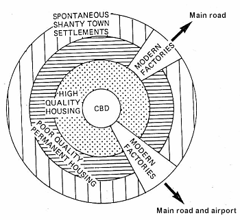
Model of Saõ Paulo (simplified urban structure)


See: Zomba Urban Model | LEDC Urban Land Use for an LEDC urban model case study


  Copyright © 2008 All Rights Reserved Barcelona Field Studies Centre S.L.  
Page update 13/05/08