Expand All  |  Collapse All
 
GCSE
Coursework
Coursework Helpline
El Raval
Planning
Designing
Introduction
Data Collection
Data Presentation
Analysis
Organisation
Edexcel A Exam
Syllabus
Assessment Scheme
Assessment
Core Paper
A1 Physical
A2 Human
A3 Economic
A4 Natural World
Option Paper
B5 Environment
C8 Urban
Revision
Core Paper
A1 Physical
1.1 Rivers
New item
1.2 Glaciation
New item
1.3 Coasts
New item
A2 Human
2.1 Pop Change
DTM
Change
2.2 Pop Structure
Dependency
Ethnic
LEDC/MEDC
Rural/Urban
2.3 Settlements
LEDC Land Use
MEDC Land Use
Site & Situation
Urban Zones
Zomba
A3 Economic
3.1 Sectors
Structure
3.2 Farming
Systems
Factors
EU
LEDC
3.3 Industry
Location
Location Change
High Tech
Formal/Informal
TNC
A4 Natural World
4.1 Weather
Air Masses
Frontal Rain
Relief Rain
Anticyclones
Synoptic Charts
4.2 Climate
Climate Factors
Climate Types
4.3 Forests
Distribution
Adaptation
Case Study
Option Paper
B5 Environment
Barton on Sea
Causes & Effects
Management
Evaluation
Rhine Floods
Background
Causes
Effects
Management
Evaluation
Farming
East Anglia
Causes & Effects
Evaluation
Sahel
Causes & Effects
Evaluation
Exploitation
Doρana
Causes & Effects
Issues
Rain Forest
Timber Extraction
C7 Tourism
Growth
Multiplier Effect
Causes
Classification
Impact
Impacts
Machu Picchu
Attractions
Impacts
Groups Affected
Sitges
Attractions
Impacts
Groups Affected
Management
Contrasts
Machu Picchu
Attractions
Management
Attitudes
Maldives
Attractions
Management
Attitudes
Yosemite
Attractions
Problems
Management
Attitudes
C8  Urban Areas
Barcelona
Inner City
Urban Sprawl
Management
Pollution
Causes
Management
Attitudes
Sao Paulo
Management
Glossaries
Coasts
Farming
Glaciation
Industry
Population
Rivers
Settlement
Urban
Weather
Tests
Air Masses
Anticyclones
Coasts
Glaciation
Grid References
LEDC Urban Land Use
Map Bearings
Map Reading
Population Change
Population Structure
Rainforest Management
Rainforest Vegetation
Rivers
Weather at a Front
Test Users Online
Active Test Users
Change Name
Chat
Your Data
Your Data Log
Other Support
Classroom Support
Classroom Support
Coursework Examples
Coursework Helpline
Site Data
Password Protection
Extended Learning
A Level
Map Reading
Year 7
Year 8
Year 9
Fieldwork
Data presentation
Methodology
Sampling
Techniques
Geography Links
Web Links
Test Support
Capital Cities
Describing Places
Glossaries
Map Reading
Open or Free Text
Test Troubleshooting
Using a Compass
Home Page
Availability | Prices 2008 | Prices 2009
 

Yosemite: Attitudes to Management

•  With development and a boost in domestic travel after the Sept. 11 terrorist attacks, visits to the Park are increasing and changing direction. The Park sees 3.5 million visitors annually. Thirty years ago, 80 percent of Yosemite's visitors stayed overnight; now, it's 80 percent day-use.

Thick smog hides Yosemite Valley

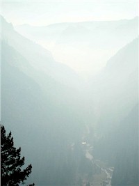
•  The number of roads and facilities have been increased to keep pace with the growing visitor numbers and to supply amenities, infrastructure and parking lots for all these tourists. These actions have caused habitat loss in the park and are accompanied by various forms of pollution including air pollution from car emissions. Environmentalists have reported "smog so thick that Yosemite Valley could not be seen from the air". This occasional smog is harmful to all species and vegetation inside the Park. (Source: Trade and Environment Database)

•  Vehicle traffic has increased about 30 percent over the last decade. Seven bears were killed by cars on park roads in 2003.

•  Development continues to encroach on park boundaries, bringing new housing projects and commercial construction - and thousands more people. The newly opened Chukchansi Casino, one of the state's largest, is just 30 miles down the road, advertising with billboards throughout the region: "Now, Yosemite has a night life." And with the recently approved SilverTip Resort Village, a 47-acre commercial and residential complex slated to go up in the tiny park border town of Fish Camp.

•  Noise pollution from vehicles and campsites rivals the Park's natural noises (Yosemite National Park Planning Update). Buildings, roads, and parking lots

Eroded river banks close to camp sites
Eroded river banks near camp sites
have marred the aesthetic beauty of the Valley, while visitors are often stuck in traffic hoping to find a parking spot.

•  Areas of river banks close to camp sites have been eroded by visitors, destroying natural habitats.

•  The importance of tourism to the local economy can be illustrated by the impact of the catastrophic 1997 floods that temporarily closed the Park. This caused locally severe economic losses to the areas around the Park. In the most heavily impacted area, Mariposa County, 1997 personal income was reduced by an estimated US$1,159 per capita (US$18 million for the entire county) - a 6.6% decline. The county was also estimated to have lost US$1.67 million in county occupancy and sales tax revenues, and 956 jobs, a significant number in a county of fewer than 16,000 residents.

• The Ahwahneechee indigenous Indians have not received any compensation in the form of money nor land for their loss of the Yosemite area in 1851.

2007 Update: Yosemite court battle ponders access vs. protection

•  Court to hear arguments on how much protection Yosemite National Park needs
• Judge's ruling in November stopped construction projects; appeal pending
• Debate: Should number of visitors be limited to protect park's resources?
• Opponents say if access limited, park will be playground for the rich

more

Sources:

thedesertsun.com | Yosemite presses on with massive restoration
Environmental Impacts of Tourism - UNEP Tourism

 
  Copyright © 2008 All Rights Reserved Barcelona Field Studies Centre S.L.  
Page update 13/05/08