Urban Land Use Patterns: MEDCs
Geographers tried to make sense of the patterns made by urban areas and devised a number of models which urban areas in MEDCs could be compared to. These definitions apply to all the models.
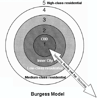
Zone 1: Central Business District; contains the major shops, offices and entertainment facilities.
Zone 2: Inner city area (twilight zone). This is an area of old housing and light manufacturing industry.
Zone 3: Low class residential. This is an area of poor quality housing, although the conditions are better than in Zone 2.
Zone 4: Medium class residential. This is an area of housing which was built between the wars. It is mainly semidetached housing and council estates.
Zone 5: High class residential (commuter zone). This is an area of expensive housing on the outskirts of the city. It also stretches in to the countryside beyond the city.
The concentric ring model (below) was devised by Burgess. It split the land use of the city into rings, starting from the centre. The idea was that urban areas grow equally in all directions.
 |
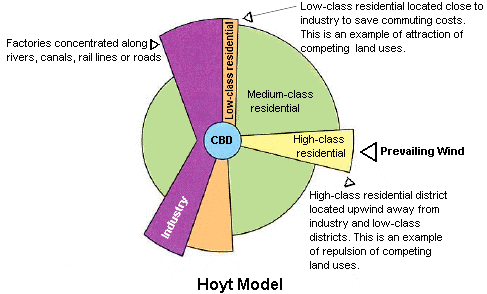
The Hoyt model (below) has land use concentrated in wedges or sectors radiating out from the city centre. For example, factories may be concentrated along a river, canal or road to form a zone of industry. This would attract low-class housing, but repel high-class residential land use.
 |
There are three explanations for these land use patterns.
1 Historical
The urban area expanded outwards from the original site which is where the city centre is found today.
2 Economic
Rents and rates in the CBD became too expensive for people. In the suburbs there was more land and it was cheaper. Only businesses could afford to stay in the CBD, but even they needed to make the most of expensive land by building upwards.
3 Concentrations of similar land uses
One part of the urban area may have all the advantages for industrial location so that a lot of factories want to locate there; but few people want to live next door to a factory, so the residential areas are located elsewhere. Planners also prefer this segregation of land uses into definite zones.
Urban Land Use Patterns: Barcelona
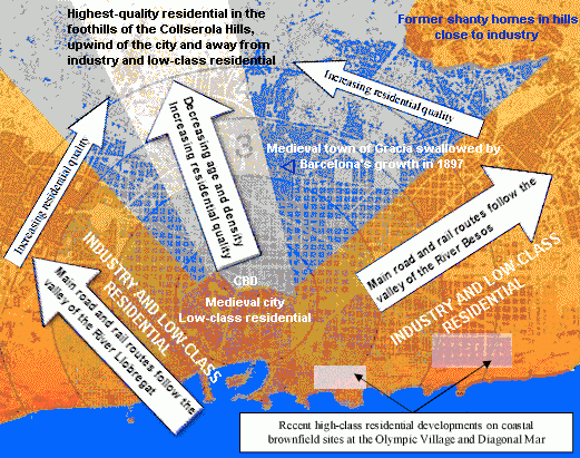
The urban land use model of Barcelona (below) is a composite of Burgess and Hoyt.
Areas with generally lower class housing and socio-economic groups include the medieval Old Town and areas of the city that experienced significant growth during the Industrial Revolution and the chaotic unplanned development that followed. Industry and low-class residential areas are located along the coast or the two river valleys that provide access to the city through the coastal mountain range.
The high-class residential areas of the city fan out from the city centre to the elevated area of Zona Alta in the foothills. Here, residents enjoy cleaner air and less humidity, helped by a northerly prevailing wind. Slightly poorer housing is found in the valleys. Pedralbes is the zone for the very wealthy, with land values twenty times those of the inner city. The coastline has recently been transformed with artificial beaches and abandoned coastal industrial sites have been redeveloped as high class residential areas.
Transition zones exist between the mainly high class and low class residential areas.
 |
| The urban land use model of Barcelona |
Urban Land Use Patterns: LEDCs
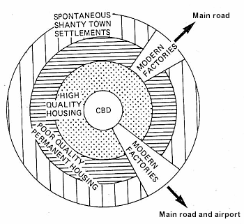
The model which has evolved is true mainly for Brazilian cities, although it can be applied to other cities in the world. The main characteristics of the model of Sao Paulo (below) are:
 |
1. The Central Business District; contains the main businesses, shopping centres and entertainment of the urban area.
2. High status housing surrounds the CBD. This includes high-rise expensive modern apartment blocks, many with their own security guards. This pattern is the opposite to that of cities in MEDCs. Inner city districts of MEDCs date back to the factories and tenement blocks of the Industrial Revolution, whereas the area surrounding the CBD in LEDCs dates from colonial times when it housed the colony's administrators and Governor. It consequently has the infrastructure - electricity, telephones, sewerage, water, etc. not found in other parts of the urban area.
3. Surrounding the high-quality residential area is poor to medium quality housing which started out as a shanty town. It has now been provided with some basic amenities (the periferia).
4. Shanty towns (spontaneous squatter settlements or favelas) are found on the steep hillsides, swamps or waste land surrounding the city.
5. Modern factories are found along main roads, sometimes with favelas in between.
There are also areas on the periphery of low-cost housing funded by the government which have basic amenities. In addition there is suburban high status, low density housing for executive and professional classes.
